
Ellhorn Rundweg
- Jan
- Feb
- Mar
- Apr
- May
- Jun
- Jul
- Aug
- Sep
- Oct
- Nov
- Dec
Media





tour_infos_headline
| Start | Balzers (Mäls) |
|---|---|
| Destination | Balzers (Mäls) |
| Distance | 8 km |
| Duration | 2:15 h |
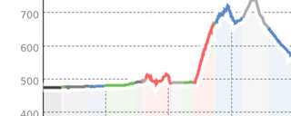
| Ascent | 260 m |
| Descent | 260 m |
| Fitness |
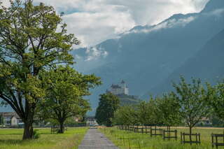
The varied Ellhorn hike offers surprising views of the villages on both sides of the Rhine and of the surrounding mountains. The flowering pastures in the Elltal valley are just as charming as the paths high above the Rhine.
From Mäls, the path initially leads us flat towards Ellhorn until the path gains height in a few bends in the forest. Via the Ellwiesen meadows, which are a botanical jewel with alpine plants such as fire lilies, gentians and Turk's cap, we reach the highest point of the hike, which is always slightly uphill. High above the vertical rocks, we enjoy surprising views down to the Rhine and Fläscher Au. We then follow the steep mountain path down through the Moxentobel to the Rhine plain. A winding path below the Ellhorn finally leads us along the Rhine back to Mäls.
Here you can find all the information about hiking in Liechtenstein at a glance!
tour_infos_headline
| Start | Balzers (Mäls) |
|---|---|
| Destination | Balzers (Mäls) |
| Distance | 8 km |
| Duration | 2:15 h |
| Ascent | 260 m |
| Descent | 260 m |
| Fitness |
Tour map
Directions
No description available.
Arrival
| Public Transport | Nearest bus stop, Balzers Brückle |
|---|
The data is maintained by the tourism destinations in Eastern Switzerland.
Entry updated on: 28.09.26, 23:07
Fehler melden (ID: tou_sx2_mq3tu71q3t-jjh)
Entry updated on: 28.09.26, 23:07
Fehler melden (ID: tou_sx2_mq3tu71q3t-jjh)
tour_infos_headline
| Start | Balzers (Mäls) |
|---|---|
| Destination | Balzers (Mäls) |
| Distance | 8 km |
| Duration | 2:15 h |
| Ascent | 260 m |
| Descent | 260 m |
| Fitness |


